Local Trail - Wolumla Peak
Trail Difficulty: Experienced
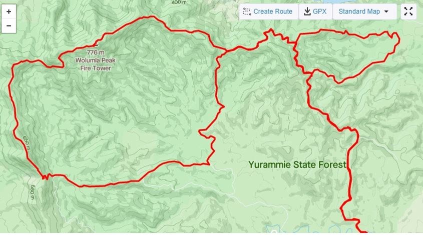
Wolumla Peak Loop - 45km
Getting there
The start point for this run is the Wolumla Peak Road turn off onto Mt Darragh Road, Lochiel (Google Maps) . However, on a hot day, you may like to make it a 42km run by choosing to start at the Pambula River Bridge which is about 1.5km along the Wolumla Peak Road. A refreshing dip after your marathon effort might be just what the doctor ordered. It is an out and back run, with plenty of optional side trails to add on or subtract distance, depending on your preference.
The track
As mentioned, this route starts near the Wolumla Peak Road turn off onto Mt Darragh Road, Lochiel. (There is a clear sign at approx. 8.5km along Mt Darragh Road indicating the Wolumla Peak Road turn off).
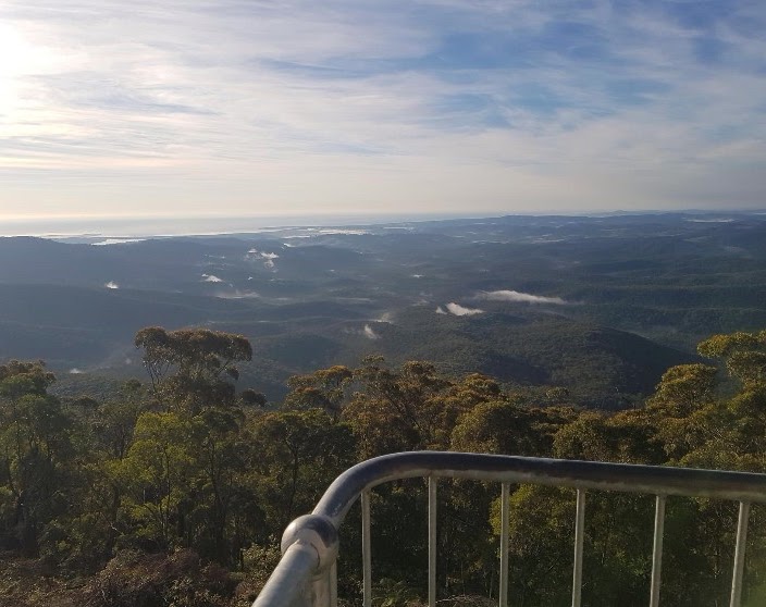
The first 16.5km follows the Wolumla Peak Road and is a gradual ascent to the top (776m Elevation) and where you’ll find the Wolumla Peak Fire Tower to take in the amazing views. (Note - If you look from the tower toward the South-West, there is a ridgeline that can be seen in the foreground extending from the North to South. This is the ‘roller coaster’ ridgeline this route follows and does provide a little perspective before setting off).
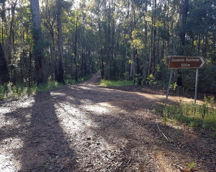
Once you’ve soaked in the views, snapped a few photos and maybe eaten a little extra sustenance, the route continues toward the West, over the peak and down the Wolumla Peak Trail. On the initial descent, the trail is quite rocky (loose and solid) but smooths out soon enough. After about 2km of descending (18.5km), the trail takes a dramatic turn upwards to steeply ascend for 1000m. Once at the top, note from here that the route heads out along that ‘rollercoaster’ ridgeline seen from the tower earlier. Continue down off this peak for another 500m (19km) to the Wolumla Peak Trail / Yurammie Link Fire Trail intersection. Continue straight down (don’t turn right) on the short Yurammie Link Fire Trail until you reach the next intersection at the Chalk Hills Fire Trail (19.5km). Follow the Chalk Hills Fire Trail straight up (don’t turn right) for the next 3.5km (23km) to another intersection. At this intersection (23km), go straight ahead (don’t turn right) and immediately veer left and down the steep, winding 700m descent. This descent will spill out onto Chalk Hills Road where you’ll see the sign for Goodenia Rainforest. Continue straight (not right toward Goodenia Rainforest) on the flat and gradual descent along Chalk Hills Road for 3km until you reach a single track off on the left-hand side of a right hand bend in the road. Exit Chalk Hills Road here and continue along this single track (called Cpt 986 Trail on Google Maps) for 2km to reach Rats Valley Road (28.5km). Turn left onto this larger dirt road and follow this for another 2km to reach another trail of a right-hand bend at the Rats Valley Road / Rats Valley Trail intersection (30.5km - not sign posted). Go straight ahead (left hand folk) and follow this rainforest trail ascent for 2.5km to close the loop back onto the Wolumla Peak Road (33km). Turn right and head back to your start point (45km); Or if you’re still feeling energetic, add some extra adventure via the many side trail options the Wolumla Peak Road has to offer.
Difficulty
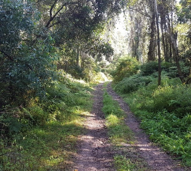
For experienced trail runners only, this is a moderate to difficult longer run – Undulating with some steeper sections – Most sections of the fire trails are smooth, open and flowy, whilst others can be (weather dependant) dry and sandy with loose and exposed rocks. Even though it is a gradual climb to the top of Wolumla Peak, there are a number of flat and downhill sections along the way to mix it up. The view at the top (especially on a clear day) is stunning and worth the effort to get there. Most of the tracks are through, predominately and quite dense, eucalypt forest, with some shallow creek crossings and small sections of rainforest.
Connections
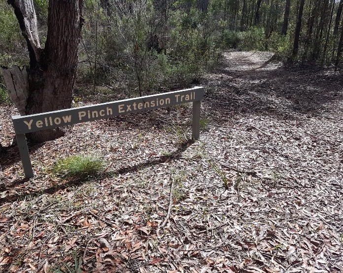
Although there are numerous trails connected to the Wolumla Peak Road, one of the more obvious and challenging of these is the ‘Challenge The Pinch Loop’ – You can add this approx. 8km loop just to add that extra “pinch” to your adventure or you might like to tackle it as a standalone?? To start this loop in a counter- clockwise direction, take the right turn onto Hakea Road off Wolumla Peak road (approx.. 7.5km from the start of Wolumla Peak Road off Mt Darragh Road), head down the gradual descent until you reach the left-hand turn onto Yellow Pinch Extension Trail and continue descending (staying left at the next sign) as it takes you out into a Powerline clearing and then back into the forest. This is where the fun starts as you’re challenged over four separate climbs until you reach the exit onto the Wolumla Peak Road. Turn left and make your way back to Hakea Road to close this loop.
Additional notes
Not to state the obvious, it is paramount that you take plenty of water, nutrition, first aid kit, including at least two compression bandages and a mobile phone if you are planning on attempting the Wolumla Peak Loop. Of course, it does depend on you and the environmental conditions as to what additional you might need, but it shouldn’t be underestimated. There are a few creeks on the Wolumla Peak Loop, but unless you plan on having a Steripen or equivalent purification, these sources may not be the healthy choice, nor necessarily reliable. You may want to consider dropping off additional water, electrolyte and food at a designated area beforehand. This is also strongly recommended. For example, either the Hakea Road or Rats Valley Trail intersections off Wolumla Peak Road will provide a good spot to have a resupply point to get you around and back to the end safely. Additional to this, it is strongly recommended that you carry a minimum of 1.5 litres of water/electrolyte around the Wolumla Peak Loop before you leave any one of these two resupply points and also have an extra 1 litre in reserve remaining at this resupply point for when you return to close the loop. This is especially important when the daily temperature forecast is expected to exceed 24 degrees.
Happy Trails!!
Back to all Trails
Please Wait, Processing Submission.
Do not refresh or leave this page until loading complete.